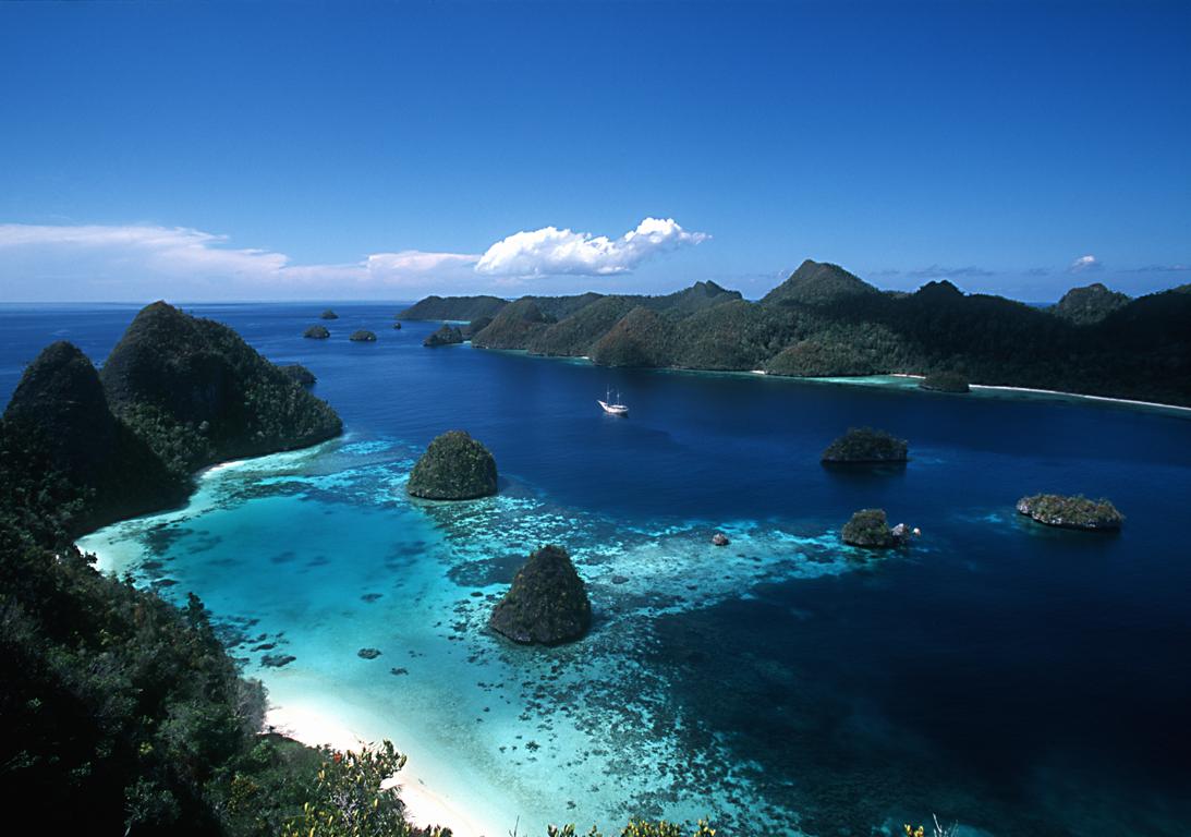
Introducing Indonesia  

Posted by Romario Mile


Introducing Indonesia

Adventure looms large in this vast and steamy archipelago, where the best of Southeast Asia’s spicy melange simmers tantalisingly. Heady scents, vivid colours, dramatic vistas and diverse cultures spin and multiply to the point of exhaustion, their potent brew leaving your senses reeling.

Rippling across the equator for nearly 5000km, Indonesia encompasses more than 17,000 islands, two-thirds of which are inhabited and richly layered with character. On Sulawesi, the elaborate funeral ceremonies and timeless traditions of Tana Toraja are light years from the surfing culture of Lombok. But so too are the mighty saddle-backed Batak mansions of Danua Toba and the volcanic lakes of Sumatra from the mummies and deeply etched gorges of Papua’s Baliem Valley. The resorts and restaurants of Bali pamper precocious style cats, while at the same moment threadbare backpackers are adopted by homestays in Kalimantan.

Indonesia’s cities are in a constant state of urban evolution, where dense populations, technology and construction live in hectic symbiosis. But most of the archipelago’s territory remains unexplored, concealing a wealth of cultures and a myriad of landscapes. Oceanic rice fields and ancient sultanates in Java are humbled by haunting volcanic cones. Maluku’s alabaster beaches and desert islands remain pristine while the tourist trail heads elsewhere. The jungles of Sumatra, Kalimantan and Papua are zoological wonders, revealing impish monkeys, stoic sun bears, leopards, orang-utans and remarkable marsupials.

And then there are the micromoments, equally exquisite but entirely unexpected; impromptu English lessons with school children, instant friendships in crammed bemos, lending an ear to your becak rider… In Indonesia there is plenty of cause to pause, except when dodging hurtling traffic – but that’s all part of the adventure.


Posted by Romario Mile

The Togian Islands

Sunset at Kadidiri - Togian IslandsB-24 wreck - propeller


Coral landscapeBarracudas at Apollo reef

GobyImperator on nudibranch

HammerheadsSponges and Jacks

FrogfishHawkfish
Diver

Pyramid Butterfly fishTwo kids at Kalumbatan

Anemone fishPaisubatu and Bobara at Una Una


From April to October, the cruises are located in the Togian Islands, inside the large Tomini Bay. The Togians include 3 main volcanic islands close together, and another one apart on the North that erupted last in 1984, as well as numerous islets. It is the only place in the world where barrier reefs, atolls, and fringing reefs are found together. Most of the islands is still covered by dense tropical forest, human settlements and tourism are still very limited.

The Togian islands dives specificity is certainly the beauty and the diversity of the underwater sceneries their offer, with a visibility that is generally very good.

Around the volcanic island of Una-Una, where we stay for 3 days, sponges size and shape diversity are astonishing, probably among the biggest in the world. The fish life is very dense: schools of jacks and barracudas, Bump head parrotfish's, numerous napoleon wrasses, snappers, fusiliers, etc.
Other dive sites include beautiful drop offs with crevasses and overhangs, canyons, rocks formations, pinnacles, all offering a great variety of spectacular underwater sceneries.

Pelagic life is present on some of the spots with schools of barracudas, tunas, giant trevallies, eagle rays, reef sharks and sometimes hammerhead sharks.

The development and the diversity of coral formations are also a highlight of the Togian islands. The cruise also includes a visit to an intact plane wreck B24 from the 2nd World War laying on the bottom at eighteen meters depth.

Our twelve days cruise, EXT TOG, covers the 8 days Togian cruise and ends in Luwuk, spending four more days of diving along the eastern tip of the peninsula that separates Tominy bay from Luwuk area. The dive sites of this area -we are the only dive operators there- are mostly rocky formations and pinnacles with an intense marine life and a high density of fishes including pelagic as tunas and giant jacks. Abundant gorgonians, soft corals and daisy corals make also those dives very colorful. For a more precise description of the Peninsula dive sites, please refer to the Banggai Cruise section.

Kadidiri bay

Examples of diving sites we visit during the Togian cruise:

NB. Most of the dive sites that are walls or slopes can be dive at different depth according to the diver's level and wishes, and if the dive is a morning or an afternoon dive. That's why we sometime mention a depth range rather than a maximum depth.

Dominik rock; Kadidiri Isl., depth 110 feet
It is a rocky formation outside the barrier reef (the barrier reef runs along almost all the north coast of Togian islands). We leave the bottom of the reef wall at a depth of 55 feet and follow the sandy bottom in between massive rocks, where we frequently spot giant groupers. The last rock, at 100 feet depth, makes a wall on its outside part falling in the deep blue, from where are coming up tunas and schools of jacks. We then follow the top of this rock that forms a flat platform covered with colorful soft corals, sponges and splendid huge gorgonians. The dive then go back to the reef wall that we follow, getting slowly up until the lagoon where we finish the dive.

Fishomania; Una-Una Isl., depth 40 - 80 feet
Una-Una is a volcanic island in the North of the Togian group. The volcano last eruption was in 1984, and since then human settlements are theoretically forbidden on the islands. In fact, a few inhabitants stay there, taking care of the numerous coconut trees on the lower part of the island, the upper part being covered by dense tropical forest.

Fishomania is a pinnacle with a top a 12 feet deep, where aggregates high densities of fishes: we generally spend a few minutes hanging on some rocks in the current, looking at the non remitting and hypnotic ballet that forms schools of fusiliers, surgeons fishes, snappers, jack fishes and so many others. The outside part of the pinnacle forms a splendid wall covered by dense coral formations of all shapes and colors, associated with sponges of uncommon size and shape.
Turtles and Napoleons are usually spotted, as well as eagle rays and white tips sharks.

Manara 1, Una-Una Isl., 45 to 90 feet
On the Una-Una barrier reef, it is a slope offering a luxuriant hard coral coverage. Another highlight of this dive is a white gorgonian field at 90 feet depth, at the beginning of the dive. Same as on the other sites of Una-Una, you will find a dense fish life all along the dive.

Apollo reef, Una-Una isl, 90 feet
A reef formation on a sandy slope, from 25 to 35 meters depth. As on the other dives on Una-Una, there is always a lot of fishes (schools of surgeons, fusiliers, Napoleon wrasses) but the highlight of the dive is huge schools of barracudas (more than one thousand ?) that comes to check and surround the divers.

Kololio, Una-una isl, 30 feet Night dive
We mention this night dive because in addition to the critters, we generally see turtles, sleeping parrot fishes -including bump head parrot- wrasses, and many other fishes interesting for portraits.

Mimpi Ding-Ding, Pasir Tengah atoll, depth 65 to 100 feet
You dive straight down along an absolutely vertical wall that goes down to abyssal depth (but not you, even though the temptation is hard to resist!). The deep and transparent blue of the water -the visibility is generally excellent- gives to this dive a special fantasy ambient. This the archetype of the "wall", where hang huge tubes and barrel sponges , black corals, where are cruising tunas, eagle rays, ascending and descending schools of Platax and trevallies. The wall also presents beautiful overhangs and crevasses. This a also a typical dive profile of the tropics where you slowly get up along the wall and finish your tanks at the top of the reef looking at the aquarium.

Goa-goa, Pasir tengah atoll, depth 55 feet
Another wall, with a lot of overhangs and horizontal faults. A very good site for photographers, with a good coverage of soft corals. A large swim through at 40 feet deep, with walls and ceiling covered by bright yellow siphonogorgias. The wall between 6 and 3 meters, where we spend the last twenty minutes of the dive, is colonized by an amazing quantity of various nudibranches.

Batu Gila ("Crazy stone"), 100 feet
A special spot for pelagics outside the barrier reef of Kadidiri. A reef with a top at -27 mts, on a sandy bottom of about 70 mts. When the currents are strong at certain periods of the tide, the fish life is very dense: Schools of jacks, barracudas, white tips, grey reef sharks and sometime hammerheads. Due to the strong currents , this dive is only offered to experienced divers.

Gunung laut, South Togians, Depth 80 feet
Coming up from a bottom of more than 200 meters, this pinnacle that culminates at -27 meters is visited by numerous pelagic fishes: tunas, white tips and grey reef sharks, schools of jacks. Beautiful coverage of soft corals.
This area has several pinnacles that are probably all good diving sites, but we practice only two of them. Some room for exploration, mention it on board if you are interested.

B24 liberator, South Togians, depth 60 feet
The wreck, a American B24 bomber from the Second World War, lays almost intact on a 18 meters bottom. The plane was on its way back to its base on Morotai Island (North Mollucas) when an engine went on fire. The pilot managed to alight on the waters of this calm bay. All the crew was safe and went to the land where the local people rescued them.
A large school of jacks is always on the spot; shrimps, glass fishes, crocodile fishes.


For more information : http://www.wallacea-divecruise.com/togians.html

Mount Bromo  

Posted by Romario Mile


Mount Bromo

Bromo isn't the highest mountain in Java — that honor goes to nearby Mount Semeru at 3,676m — but it's probably the most famous one. Bromo is in fact only one of many peaks inside the massive Tengger Caldera, but it's easily recognized as the entire top has been blown off and the crater inside constantly belches white sulphurous smoke. The inside of the caldera, aptly dubbed the Laut Pasir (Sea of Sand) is coated with fine volcanic sand and the overall effect is unsettlingly unearthly, especially when compared to the lush green valleys all around the caldera.

Orientation

The major access point is Cemoro Lawang at the northeast edge, but there are also trails from Tosari (northwest) and Ngadas (west). The village of Ngadisari, on the road from Probolinggo about 5.5 km before Cemoro Lawang, marks the entrance to the national park. Both Cemoro Lawang and Ngadisari are rather picturesque, with brightly-painted houses and flower beds outside.


See & Do

Mt. Batok and the Sand Sea in the Tengger Caldera

Mt. Batok and the Sand Sea in the Tengger Caldera

When timing any activities in the area, bear in mind that sunset is soon after 5 PM and sunrise is correspondingly early at around 5:30 AM. This means you'll usually need to get up by 3:30 AM or so to get there in time for dawn.

  • Mount Batok (2440m) is a brown volcanic cone at the north center of the caldera. Unlike the other nearby peaks it is no longer active and actually has some vegetation growing on it, mostly the local cemara tree that somehow manages to survive even on volcanic ash.
  • Mount Bromo, edges tinged with white sulphur and always bubbling, is the main sight. To reach it on foot, pick the left fork at Cemoro Lawang's solitary crossing, then head down the ramp into the caldera and then across the caldera to the Hindu temple at the foot of the mountain. From the temple a steep path of 250 steps leads to the edge of the crater and a precarious meter-wide ledge from where to gaze into the volcano. Beware of local jeep-hirers, who often try to persuade tourists the journey to the mountain is not walking distance (in order to hire them jeeps, or horses). The walk from the tourist centre to the top of the mountain should take no longer than 1.5 hours by foot, and is about 3km.
  • Mount Penanjakan (2770m), located just north of the caldera, is a mountaintop viewpoint accessible by paved road from Tosari and hence popular with jeeps and even tour buses. Most of the crowd comes to see the dawn at 5 AM, and you'll likely have the large concrete observation post to yourself if you arrive later in the day.
  • Viewpoint #2, along the trail from Cemoro Lawang to Mt. Penanjakan, is an excellent way to get a stunning view of the caldera (see pictures above) without the crowds. To reach it, head west from Cemoro Lawang (past Cemero Indah) for 6 km, past farms and fields. The paved road eventually turns into a twisty mountain trail that ends with a flight of stairs on the right, and the viewpoint (with concrete shelter) is at the top. Allow 1.5 hours for the climb up at a steady pace, and bring along a torch if attempting this at night.
    • From here, you can continue onto Mt. Penanjakan by following the trail upward, after which the trail merges onto the paved road to the viewpoint (total time about 60 minutes one way). If planning to return the same way, mark the spot where the trail emerges onto the road (if you pass a stone lantern on the way down, you've gone too far!), and note that descending on this section can get slippery due to loose sand and rocks.

The Raja Ampat Islands  

Posted by Romario Mile


The Raja Ampat Islands
In the Heart of the Coral Triangle


The Raja Ampat, or “Four Kings,” archipelago encompasses more than 9.8 million acres of land

and sea off the northwestern tip of Indonesia’s West Papua Province. Located in the Coral Triangle, the heart of the world’s coral reef biodiversity, the seas around Raja Ampat possibly hold the richest variety of species in the world.

The area’s massive coral colonies show that its reefs are resistant to threats like coral bleaching and disease —threats that now jeopardize the survival of corals around the world. In addition, Raja Ampat’s strong ocean currents sweep coral larvae across the Indian and Pacific Oceans to replenish other reef ecosystems. Raja Ampat’s coral diversity, resilience to threats, and ability to replenish reefs make it a global priority for marine protection.

Survey Confirms Highest Marine Biodiversity on Earth

In 2002, The Nature Conservancy and its partners conducted a scientific survey of the Raja Ampat Islands to collect information on its marine ecosystems, mangroves, and forests. The survey brought Raja Ampat’s total number of confirmed corals to 537 species— an incredible 75% of all known coral species. In addition, 899 fish species were recorded, raising the known total for Raja Ampat to an amazing 1,074. On land, the survey found lush forests, rare plants, limestone outcroppings, and nesting beachesfor thousands of sea turtles.

Though human impacts here are less severe than elsewhere in Indonesia, Raja Ampat’s natural resources are endangered by over fishing and destructive fishing, turtle poaching, and unsustainable logging. The Indonesian government recently established Raja Ampat as a separate administrative unit, which will give communities a greater say in managing the natural resources upon which their livelihoods depend. This structure also offers an important opportunity to include conservation in the spatial planning of the newly formed local government.

Ensuring Conservation through Partnerships

To address these issues, the Conservancy launched a new project to protect Raja Ampat, working in close partnership with the government and communities to: 1) contribute to a comprehensive conservation action plan to protect Raja Ampat’s reefs and forests; 2) help incorporate marine protected area management into long-term planning and policy; and, 3) establish a network of marine protected areas for Raja Ampat.

The Conservancy’s ultimate goal is to protect Raja Ampat’s magnificent reefs while sustaining the livelihoods of local people. Raja Ampat includes the four large islands of Waigeo, Batanta, Salawati, and Misool, plus hundreds of smaller islands. The archipelago is part of an area known as the Bird’s Head functional seascape, which also contains Cenderawasih Bay, the largest marine national park in Indonesia.

Bunaken Island  

Posted by Romario Mile


Bunaken National Marine Park

GENERAL INFORMATION

Bunaken is one of Indonesia's most famous dive/snorkeling areas, and it draws scuba divers & snorkelers from all over the world. In addition to Bunaken itself, a rather featureless banana-shaped island, the National Park includes the neighboring islands of Manado Tua, a distinctive cone-shaped extinct volcano, Siladen, Montehagen, Nain, and Nain Kecil.The Bunaken National Marine Park was formally established in 1991 and is among the first of Indonesia's growing system of marine parks. The park covers a total surface area of 89,065 hectares, 97% of which is overlain by sparkling clear, warm tropical water. The remaining 3% of the park is terrestrial, including the five islands of Bunaken, Manado Tua, Mantehage, Nain and Siladen. Although each of these islands has a special character, it is the aquatic ecosystem that attracts most naturalists.

The waters of Bunaken National Marine Park are extremely deep (1566 m in Manado Bay), clear (up to 35-40 m visibility), refreshing in temperature (27-29 C) and harbor some of the highest levels of biodiversity in the world. Pick any of group of interest - corals, fish, echinoderms or sponges - and the number of families, genera or species is bound to be astonishingly high. For example, 7 of the 8 species of giant clams that occur in the world, occur in Bunaken. The park has around 70 genera of corals; compare this to a mere 10 in Hawaii. Although the exact number of fish species is unknown, it may be slightly higher than in the Philippines, where 2,500 species, or nearly 70% of all fish species known to the Indo-western Pacific, are found.

BUNAKEN NATIONAL PARK ENTRANCE FEE:

Bunaken National Park Entrance Fee Tag All visitors to the Bunaken National Park (divers and non-divers) are required to pay an entrance fee, in accordance with North Sulawesi Provincial Government Provincial Law Number 9/2002. The entrance fee for foreign visitors is Rp 50,000 per daily ticket (approximately US$6), or Rp 150,000 (approximately US$17) for a waterproof plastic entrance tag valid for the full calendar year.

Entrance tags and tickets can be purchased direct from all NSWA members, or from ticket counters on Bunaken Island and on Siladen Island. They must be carried at all times that guests' are within the park boundaries, and tags can easily be affixed to guests' diving or snorkeling gear or on backpacks. Enforcement of the entrance fee system is conducted via spot checks by park rangers on land and at sea.

The entrance fee system has been adapted from the well-known Bonaire Marine Park system, and the proceeds from the sales of the entrance tags are managed by the Bunaken National Park Management Advisory Board (BNPMAB), a multi-stakeholder board that NSWA is a member of. The system has been very successful in raising over $250,000 for conservation programs in the Bunaken Marine Park since its inception in 2001.

Please read: The Bunaken Entrance Fee - Questions and Answers

Oceanic currents may explain, in part, why Bunaken National Marine Park is such a treasure trove of biodiversity. Northeasternly currents generally sweep through the park but abundant counter currents and gyros related to lunar cycles are believed to be a trap for free swimming larvae. This is particularly true on the south side of the crescent-shaped Bunaken Island, lying in the heart of the park. A snorkler or diver in the vicinity of Lekuan or Fukui may spot over 33 species of butterfly fish and numerous types of groupers, damsels, wrasses and gobies. The gobies, smallish fish with bulging eyes and modified fins that allow them to attach to hard surfaces, are the most diverse but least known group of fish in the park.
Biologists believe that the abundance of hard corals is crucial in maintaining the high levels of diversity in the park. Hard corals are the architects of the reefs, without them, numerous marine organisms would be homeless and hungry. Many species of fish are closely associated with particular types of corals (folious, branching, massives, etc.) for shelter and egg-laying. Others, like the enormous Bumphead Parrotfish, Balbometopon muricatum, are "coralivores" and depend on hard corals for their sustenance. Bony mouth parts fused into an impressive "beak" allow these gregarious fish to crunch corals like roasted peanuts.
Some 20,000 people live on the natural resources of Bunaken National Marine Park. Although there are inevitable conflicts between resource protection and use by people, the Indonesian government is taking a fairly unusual and pragmatic approach to park management. The idea is to promote wise resource use while preventing overexploitation. Local communities, government officials, dive resort operators, local nature groups, tourists and scientists have played an active role in developing exclusive zones for diving, wood collection, fishing and other forms of utilization. If successful, Bunaken Marine Park will stand as an important example of how Sulawesi, and the rest of Indonesia, can work to protect its natural resources.

Accommodation and Transfer
On the island you have the choice amongst a number of homestays, with rates starting at around Rp. 50 000 per day and person incl. fullboard. If you only go for the cheapest option don't complain afterwards if the water in your mandi (bathroom) doesn't get filled up regularly, or food isn't quite as nice as you had hoped for. Life in North Sulawesi in general isn't as cheap as in other regions of Indonesia, and most things on Bunaken have to be brought in from Manado. Depending on the season even fish can be pretty expensive. Better think twice before you try to bargain down prices which are already cheap; for the locals it could mean the difference between being able to eat 3 or only 2 meals a day, or buying school books for the children or not.
Some of the dive operations on Bunaken are offering more upmarket accommodation, even hot showers (Living Colours, Cha Cha Nature Resort).

Some guesthouses ("homestays") on Bunaken:
Pangalisang Beach: Lorenso's Homestay
Liang Beach: Panorama, Nelson's, Papa Boa
There are a lot more...

Bunaken's much smaller neighbour Siladen only offers few accommodations. Most popular among budget travelers seems to be Martha's Homestay.
The most upmarket resort within the boundaries of the Bunaken National Park is Siladen Resort & Spa which started operations in 2003. The eco-friendly luxury boutique resort places high emphasis on the protection of the Marine Park and the environment.

! The public boats from Manado to Bunaken are leaving daily around 2 p.m (depending on tide), except Sundays, from Pasar Jengki near Manado harbour. Back from Bunaken to Manado usually early in the morning, around 7-8 a.m. Even on Sundays there might be boats, just go to the harbour and ask people there. To charter a boat is about Rp. 150,000 - 200,000 OW. If you want to go to Siladen it is better to inquire first at the harbour, but usually there are several boats as well. The fare to Siladen is also Rp. 15 000.

Bunaken - Scuba Diving

A growing number of dive centers is operating from the mainland around Manado and directly from Bunaken Island. Generally spoken you should rather pay a few dollars more and go for safe and experienced operators than just choose the cheapest option. Tank fillings can be a problem, and headaches after each dive give you a clear sign that your dive operator saves money on filters; better go somewhere else if you experience this.

North Sulawesi Watersports Association In general diving standards in North Sulawesi are high, as is environmental awareness among the dive operators, at least the ones who have formed the North Sulawesi Watersports Association, NSWA. The NSWA has made significant strides in improving the management and conservation of Bunaken National Park and surrounding marine ecosystems and in conferring concrete benefits of tourism to the villagers living within the park. Many of its members have spent a lot of their money and time for various ecological and social achievements within the park. This has not gone unnoticed; recently the Bunaken National Park has received the "Tourism for Tomorrow Award" and the "UN Equator Prize" (more on www.divenorthsulawesi.com).
Unfortunately some stupid backpackers still think that they know everything better than these international organisations and refuse to pay the entrance fee to the National Park. If you are planning to do this, please stay away. You are not welcome - the National Park needs support, not ignorance!

Komodo Island (KOMODO DRAGON)  

Posted by Romario Mile


“The Komodo dragon, as befits any creature evoking a mythological beast, has many names. It is also the Komodo monitor, being a member of the monitor lizard family, Varanidae, which today has one genus, Varanus. Residents of the island of Komodo call it the ora. Among some on Komodo and the islands of Rinca and Flores, it is buaya darat (land crocodile), a name that is descriptive but inaccurate; monitors are not crocodilians. Others call it biawak raksasa (giant monitor), which is quite correct; it ranks as the largest of the monitor lizards, a necessary logical consequence of its standing as the largest lizard of any kind now living on the earth…. Within the scientific community, the dragon is Varanus komodoensis. And most everyone calls it simply the Komodo.” Claudio Ciofi

The Komodo dragon is an ancient species whose ancestors date back over 100 million years. The varanid genus originated between 25 and 40 million years ago in Asia. The Komodo descended from this species and evolved to its present form over four million years ago.

The Komodo is long lived (as are most of the larger reptilian species) with an estimated life expectancy of over 50 years in the wild. In keeping with its longevity, the Komodo matures late in life, becoming sexually viable at five to seven years, and achieving maximum body density in fifteen years. Komodos are sexually dimorphous, which means males are bigger than females. The largest recorded specimen was 3.13 meters in length and was undoubtedly a male. Females rarely exceed 2.5 meters in length. What is perhaps more important, is that the characteristic bulk is achieved by older dominant males in clearly delineated territorial areas. As an adult Komodo can consume up to 80% of its body weight in one gorging, weight is a highly variable factor, and is largely dependent on the most recent feeding. A typical weight for an adult Komodo in the wild is 70 kilograms.

Komodo dragons are first and foremost opportunistic carnivores, and predators second. Although the Komodo can sprint briefly at 20 kilometers an hour, it does not chase down game as do the larger mammalian predators. The Komodo is a stealth predator, which lies motionless and camoflouged alongside game trails for the unwary, which tend to be the very young, the old and the infirm. In an attack, the Komodo lunges at its victim with blinding speed and clasps it with the serrated teeth of the jaw. Prey are rarely downed in the initial attack unless the neck is broken or caratoid artery severed. The more likely outcome is escape, followed by death a few hours or days later from septicemia introduced by the virulent strains of bacteria found in the saliva of the Komodo dragon (the Komodo survive primarily on carrion and ingest the bacteria when feeding).

The Komodo has two highly developed sensory organs – the olefactory and the Jacobson’s - which allow the dragon to detect rotting carcasses from distances as great as 10 kilometers. The yellow forked tongue isconstantly being flicked in and out of the mouth, “tasting the air”, and inserted into the Jacobson’s organ located in the roof of the mouth. The individual tips are highly sensitive and are capable of discriminating odors in the magnitude of millionths of a part. Using the information garnered, the dragon wends in a seemingly random, winding path which becomes straighter the closer it approaches to the carrion. The Komodo is typically a communal feeder and any number of dragons might arrive at the site of the carcass.

Socialization occurs during feeding at carrion sites, as does mating. The abdomen is slashed first and the intestines and stomach contents scattered. Young juveniles roll in the fecal matter to mask their scent from aggressive adults, which attack and sometimes kill juveniles during feeding. The dominant male feeds until sated, followed by other dragons in order of size. While the dominant male is gulping down hindquarters and ribcages, the braver dragons chance foraging a few scraps. Virtually the entire carcass is consumed in the process– head, fur, hooves and bones. After feeding, the Komodos become quiescent and approachable while their digestive tracts are converting the food into fat energy stored in the tail.

Between the months of May and August, mating occurs at and around feeding sites. As males outnumber females in a ratio of nearly four to one, the dominant male must fend off other suitors before mating. Males will engage in slashing, biting and bipedular rearing onto the tail, until the dominant male is acknowledged by displays of subservience and the vanquished flees. The female is forced into a prone position while the male tongue flicks her body, and in particular, the fold between the torso and the rear leg close to the cloaca. With Komodos, the male hemipenes are located here as are the female genetalia. Once prone, the male mounts onto the back of the female and inserts one of the two hemipenes into her cloaca , depending on which side he is perched. The month of September is when a clutch of 15-30 eggs is buried in a nest dug with the powerful claws of the female dragon. A typical nesting site is in the composting vegetative mounds of the maleo birds which are indigenous to Komodo.

The gestation period for the eggs is eight to nine months. Hatchlings, which average 40 centimeters in length and weigh 100 grams, emerge from the nest in April and immediately scramble up the nearest tree to avoid being eaten by the adults. There are plenty of small lizards, insects and mammals in the canopy after the brief rainy season in January and February to sustain the juveniles until they descend to the forest floor roughly a year later. This period of change between an arboreal and a terrestial habitat, when the juveniles are a meter in length, is a time fraught with danger. The juvenile Komodo is just too bulky to safely ascend many trees, and not big enough to outrun a ravenous and determined adult. Cannibalism is a fact of life for this species, and perhaps is an evolutionary response to the harsh, arid climate of Komodo.

Prey species for the dragon on Komodo island include deer, boar, wild buffalo, the maleo bird, snakes, reptiles and small mammals. On Rinca, the monkeys and wild horses found there are also constitute prey, as do the goats raised by the local people. On the odd occasion people are also attacked by the Komodo dragon. There have been eight recorded instances of attacks on humans since Komodo has become a national park, almost all of which occurred on Rinca.

Park Facilities
The Komodo National Park administrative offices are located in Labuanbajo in west Flores. An information center and travel agents where transportation to and from the Park can be arranged are also found in Labuanbajo. The majority of tourists to the Park pass through the Loh Liang ranger station nestled in the sweeping arc of Slawi Bay on Komodo island. This is the largest facility in Komodo National Park with bungalows and rooms, a restaurant and a dormatory for the park rangers. The most popular tourist activity is a hike to the Banugulung viewing area, a two-hour roundtrip level walk that originates from Loh Liang. Hikes to other areas of Komodo are also possible, and vary from one to two days: Gunung Ara, Poreng, Loh Sebita, Gunung Sata libo, Soro Masangga. On longer walks overnight accommodation can be arranged at ranger posts at Loh Sebita and Loh Genggo. For certified divers there is a compressor and diving equipment available for hire at Loh Liang as well as masks and fins for snorkellers. Handicrafts made in the nearby village of Komodo are for sale at the arrival jetty.

The entrance ticket to Komodo National Park costs Rp 20,000 and is valid for three days. It is easily renewable, so a prolonged stay in the park is possible. There are two ranger stations which provide spartan accommodation for tourists: Loh Liang on Komodo and Loh Buaya on Rinca. The charges are minimal and start at Rp 30,000 per room. Be advised that everything is basic, including beds, communal toilets and food availability. Fortunately most travellers are not deterred by the limited facilities, accepting this as a part of the Komodo experience. Advance booking for accommodation are not accepted.

The hiking on Rinca is less strenuous than that on Komodo, and has the added attraction of viewing the wild horses and monkeys which are not found on Komodo. On Rinca wild buffalo are more common and easily seen as well. On the north side of the island, behind Rinca village, is a large cave with a resident bat colony. Rangers at both Loh Liang and Loh Buaya are readily available to lead walks, and are knowledgeable about the local fauna and birdlife.

Introducing Lombok  

Posted by Romario Mile


Introducing Lombok

Lombok is the most popular destination in Nusa Tenggara, with the fabled Gili Islands drawing visitors for action both in and out of the water, mighty Gunung Rinjani luring trekkers, and the big breaks on the south coast a magnet for surfers. Matram, Lombok's capital, is a good spot for day trips to the surrounding areas, and nearby Senggigi is superbly positioned along a stretch or sweeping bays. In east Lombok, the very scenic Sumbawa offers low key tourism and some good surf breaks.

The island of Lombok shapes up at about 80km from east to west and about the same from north to south, with lush evergreen landscapes and parts which are chronically dry. Droughts, particularly in the south and east, can last for months, causing crop failure and famine – though recent improvements in water management have made life in Lombok less precarious.

Rice is an important crop, though yields are lower here than on neighbouring islands. Tobacco, coconuts, coffee, kapok and cotton are also important crops, while cloves, vanilla, pineapple and pepper have also been introduced.

The indigenous Sasak (around 90% of the population) are Muslims but have a culture and language unique to Lombok. There’s also a significant Hindu Balinese minority – a legacy of the time when Bali controlled Lombok.

Introducing Bali  

Posted by Romario Mile

Introducing Bali

Bali may be small in size – you can drive around the entire coast in one long day – but its prominence as a destination is huge, and rightfully so. Ask travellers what Bali means to them and you’ll get as many answers as there are flowers on a frangipani tree. Virescent rice terraces, pulse-pounding surf, enchanting temple ceremonies, mesmerising dance performances and ribbons of beaches are just some of the images people cherish.

Small obviously doesn’t mean limited. The manic whirl of Kuta segues into the luxury of Seminyak. The artistic swirl of Ubud is a counterpoint to misty treks amid the volcanoes. Mellow beach towns like Amed, Lovina and Pemuteran can be found right round the coast and just offshore is the laid-back idyll of Nusa Lembongan.

As you stumble upon the exquisite little offerings left all over the island that materialise as if by magic, you’ll see that the tiny tapestry of colours and textures is a metaphor for Bali itself.

And those are just some of the more obvious qualities. A visit to Bali means that you are in the most visitor-friendly island of Indonesia. There are pleasures of the body, whether a massage on the beach or a hedonistic interlude in a sybaritic spa. Shopping that will put ‘extra bag’ at the top of your list. Food and drink ranging from the freshest local cuisine bursting with the flavours of the markets to food from around the globe, often prepared by chefs and served in restaurants that are world class. From a cold Bintang at sunset to an epic night clubbing in Kuta, your social whirl is limited only by your own fortitude.

Indonesia Travel